Slow Travel, Conservation, and Birdwatching Best Practices Across Canada Simple, ethical birding practices for low-impact wildlife travel across Canada A Guide to Respectful Birding Etiquette in Canada is essential readi...
Why VIA Rail's The Canadian in Winter Is Canada's Ultimate Slow Train Adventure Discover the Magic of Canada's Winter Landscapes on a Five-Day Cross-Country Rail Journey Riding VIA Rail's The Canadian in Winter: Tor...
Why eh Canada Travel Is Canada's Go-To Adventure Planning Website Where Canadian Stories, Practical Planning, and Real Adventure Come Together What Makes eh Canada Travel the Best Adventure Planning Website in Canada - F...

British Columbia Parks and Trails

Planning adventures in our British Columbia Parks and Trails

Parks, hiking trails, historic sites, heritage sites, rivers, lakes and natural areas in BC Canada

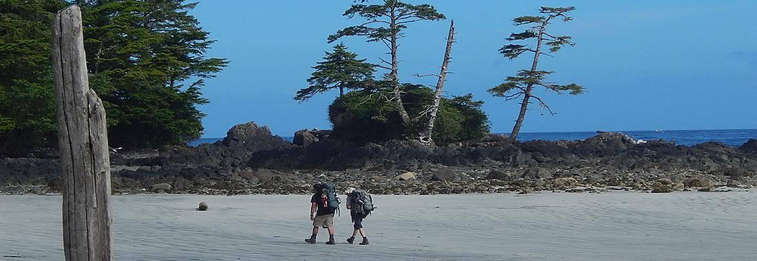
British Columbia parks and trails in Canada covers every type of landscape and seascape including mountain ranges, rivers, lakes, glaciers, forests, wetlands, wildlife, ecological and heritage. All play a big part in the creation of our BC parks system. Some of our BC Parks and heritage trails tells the long history of Canada. Others are for protection of wildlife, floral and fauna. Then there are those strictly designed for adventures and leisure living outdoors. There are over 11,400,000 hectares of BC parkland in Canada with over 2,700 kilometres of hiking and mountain biking trails.

British Columbia Parks & Trails

Over 800+ BC Parks in the province 

There are over 800 or so British Columbia parks in Canada. This, by no means, is the total number of wilderness and recreation parks in British Columbia, Canada as there are many others that do not fall under the Provincial umbrella. Other parks in the province includes a few National parks and many smaller community, regional, hyro and forestry recreation parks located throughout the province. Only 12.5% of our province is protected by BC Parks and 0.6% is protected by National Parks.

British Columbia Parks and Trails in Canada Summary

British Columbia parks and trails are used for many occasions and activities. The Khutzeymateen Provincial Park is Canada's only grizzly bear sanctuary. The Tweedsmuir Provincial Park is British Columbia's largest provincial park covering 989,616 hectares. On Vancouver Island the 440 metre Della Falls in Strathcona Park is Canada's highest waterfall and is one of the ten highest falls in the world!

Parks are an important part of our province providing thousands an opportunity to enjoy the wilderness outdoors. It is said 6 out of 10 people living in BC visit a park every year.

The British Columbia parks and recreation sites are here for yours and our tourism enjoyment. Please help us care for them and respect them. Do not leave garbage behind. Do not feed the wildlife. Always ask questions on the services, amenities, fees and rules to live by when in the park.

British Columbia Parks and Trails in Canada

Click the BC Regions below to view parks, trails and places in that area.

Cariboo Chilcotin Coast

Cariboo Chilcotin Coast Parks and Trails

Gulf Islands

Gulf Islands Parks and Trails

Haida Gwaii

Haida Gwaii Parks and Trails

Kootenay

Kootenay Parks and Trails

Lower Mainland

Lower Mainland Parks and Trails

North BC

North BC Parks and Trails

Okanagan

Okanagan Parks and Trails

Sunshine Coast

Sunshine Coast Parks and Trails

Thompson Shuswap

Thompson Shuswap Parks and Trails

Whistler Area

Whistler Region Parks and Trails
roesland-sunset
The highlights of Roesland attract people to the park. Some of the highlights include Row House (the museum), the hiking trail to the tip of Roe Islet (amazing marine views) and the hiking trail to Roe Lake located above Shingle Bay.
Read more
South Otter Bay Road
kumdis1
The Kumdis River Trail is located north east of Port Clements, adjacent the Kumdis River Bridge.
Read more
Highway 16
Port Clements
k2_trail 001
The Knob 2 hiking trail enjoys navigating the side of Mount Elphinstone (4,137 feet/1261 m).Prepare well with water and good hiking boots, as it takes 2 hours one way, 4 hours round trip and that is not taking into consideration the long picnic many enjoy at the summit
Read more
Wharf Road
Gibsons
bear-gwaii-haanas
A massive 1470 square km wilderness park which includes evidence of a deep spiritual history of the Haida people throughout the park. As, far back as 10,000 years ago, the land of Gwaii Haanas was home to the Haida people.
Read more
Sandspit
friendlycove
Nootka Island Trail is located on Nootka Island in Nootka Sound off the west coast of Vancouver Island, Canada near Gold River, BC. Nootka Island is accessed via boarding a walk on only ferry or floatplane which departs from the marina in Gold River or by kayak.
Read more
Gold River, Friendly Cove, Kyuquot
tofino 030
Cox Bay is a smaller sandy beach destination which is lesser known by tourists and more popular by the locals. Crowds are less because the waves are bigger, it is farther from Tofino and there is no direct vehicle access. Visitors arrive via a trail or by ocean kayak. Cox Bay is located south of the
Read more
Pacific Sands Beach Resort Road
Tofino
shuswaplake
First established in 1956 the 149 hectare Shuswap Lake Provincial Park is a full service destination park popular for swimming, boating, water skiing, sightseeing, canoeing, hiking, camping, snorkeling, wind surfing and fishing
Read more
Squilax Road
Sorrento
A group of islands and islets located off the coast of Bamfield. The islands are visited by sailboats, kayakers and boaters. Islands are best accessed from East Bamfield near Port Desire. A preferred destination ideal for overnight kayaking adventure tours with plenty of availabl
Read more
clayburn-creek-park
Discover Clayburn Creek Park and Trail. A forested, wilderness recreation trail exploring along the banks of Clayburn Creek, near the Village of Clayburn, located north of Abbotsford, British Columbia, Canada.
Read more
Abbotsford
barret-hat-trail02
The short 2 km or so hiking trail travels along an old overgrown forestry road leading out onto a lookout point with fantastic views of the Telkwa Mountain Range and the Bulkley Valley.
Read more
Barret Hat Road
Houston
angus_creek_trial 004
The rewards of this mountain biking route includes some fantastic views of Sechelt Inlet, Mt. Richardson, the Caren Range Plateau and of the town of Sechelt, on the Sunshine Coast, BC, Canada.
Read more
Sechelt-Crucil Service Road
Sechelt
blackwaterlake 001
Blackwater Lake near Pemberton, British Columbia, Canada is a small remote lake nestled in the forest that is located north of Pemberton and east of the community of D'Arcy, BC. The lake is mainly used as a swimming and fishing hole. There are some who stop by for a picnic.
Read more
Blackwater Lake Rd
Pemberton
maralake
Mara Lake measures just under 20 square kilometres. The lake is connected by the Sicamous Narrows to Shuswap Lake. Both lakes provide a vast waterway playground for houseboating, boating, kayaking, water skiing, paddle boarding (sup) and fishing.
Read more
Highway 97A
Sicamous
fairylake
Fairy Lake is most famous for the lonely fir tree surviving in the middle of the lake. Many photos have been taken of this little guy making a go of it under tough conditions. The lone twisted tree poking out of the lake perched on a sunken log makes for a great photo.
Read more
Harris Main FSR
Port Renfrew
iona-beach2
Iona Beach Regional Park is uniquely shaped by nature consisting of two large sand spits (jettys). The spits together have created over 20 kilometres (12 miles) of sandy coastline. The activities enjoyed in the park include birdwatching, hiking, biking, beachcombing, sightseeing, picnicking and ...
Read more
Ferguson Road
Richmond
© 2026 Eh Canada Marketing Group
Cron Job Starts