
Dempster Highway (Hwy #5)
The Dempster Highway is a transportation route connecting the Yukon Territory with the Northwest Territory in Canada. It is the only highway in Canada which explores in the Arctic Circle. It is one of the best self guided driving tours in Canada exploring up to 10 different and vital eco systems. There are sightseeing opportunities for wildlife, birds, mountains and wetlands.
There are 10 identified eco regions along the Dempster Highway. The identified eco regions include the Klondike Plateau, Yukon Plateau North, Mackenzie Mountains, North Ogilvie Mountains, Eagle Plains, British-Richardson Mountains, Peel River Plateau, Fort McPherson Plain, Arctic Red Plain and the Mackenzie Delta (Canada's largest wetland delta).
The Dempster Highway was completed in 1979. The route is separated into 7 travel sections based on the eco systems. They are the North Klondike River, Blackstone Uplands, Ogilvie River, Eagle Plain Plateau, The Richardsons, Mackenzie Lowlands and the Mackenzie Delta.
There are mountains of all types - limestone, dolomite, fossil coral, and red shale. The highway travels through the traditional territories of the Han and Gwicth'in First Nation and Inuvialuit peoples. These are the lands of the migrating Porcupine Caribou herd. The entire Dempster Highway is a lesson in history including First Nation, Beringa, Geology, Ice Age, and wildlife.
The Dempster Highway is a self guided wildlife tour. Some of the wildlife sightings may include moose, grizzly bears, caribou, mountain sheep, marmots and collared pika. There are fishing lakes and rivers full of Arctic grayling, burbot, whitefish, northern pike and Dolly Varden. 
Birding is even bigger on the Dempster. Birds include duck, plover, ptarmigan, swan, Short Eared Owl, Northern Hawk Owl, Great Gray Owl, Wandering Tattler, Golden Eagle, Long tailed Jaeger, Dark eyed Junco, Peregrine Falcon, Red Throated Loon, American Dipper, Arctic Tern and one of our favorites the Gyrfalcon.
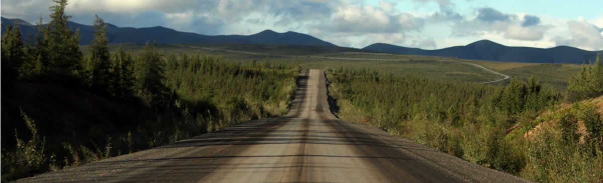
Mile"0" on the Dempster Highway begins south of the community of Dawson City, Yukon on the Klondike Highway. The route travels a one-way, gravel highway 738 kilometres to the little isolated community of Inuvik, Northwest Territory.
NORTH KLONDIKE RIVER - Kilometre Yukon 0 to 73 - The North Klondike portion of the Dempster Highway begins at Mile "0" just south of Dawson City, Yukon. Much of the route follows the Klondike River. At about the 7 kilometre point on the highway the pavement ends and gravel begins. In the distance, you can catch a glimpse of the Ogilvie Mountains. At the 20 kilometre point, look west , and there is the Klondike Mountain Range. At the 72 kilometre point you have reached the Tombstone Territorial Park. There is camping, hiking, backpacking and an information centre in the park.
BLACKSTONE - Kilometre Yukon 74 to 158 - The Blackstone Uplands portion of the Dempster Highway starts under the pointed peaks of the Tombstone Mountain Range. Soon after you are driving through the North Fork Pass which is the highest point on the Dempster measuring 1400 metres. There is a pull out at kilometre 80 for mountain views and possible wildlife sightings. Just up the road is Angelcomb Peak which is home to Dall sheep.
At the kilometre 90 marker is the beginning of the Blackstone Uplands. Visit a First Nation monument we found at kilometre 113 of two First Nation elders named Joseph & Annie Harvey. At kilometre 116 is Chapman Lake, the largest lake on the Dempster and the wintering home of the Porcupine Caribou Herd. Mid October is prime viewing time. At kilometre 120 you are leaving the Tombstone Territorial Park. After you leave the park you drive though the Tiaga Range and up through the Windy Pass Summit with the Ogilvie Mountains and arctic tundra passing you by.
OGILVIE RIVER - Kilometre Yukon 168 to 237 - The Ogilvie River Valley portion of the Dempster Highway follows Engineer Creek to Ogilvie River. This is boreal forest country with mountains. Again on this portion of the route there may be an opportunity to view Dall sheep. Binoculars are a good idea. For the next 30 kilometres you will notice some strange smells in the air. The odor comes form the minerals in the area reacting with the water and rocks. It is not hard to miss the bright orange sediment lining the river banks and the coloring of the rocks. Nor is it easy to ignore the sulfur smell in the air. Who farted?
The odor derives form the creek water interacting with the minerals in the rocks producing water with high concentrations of chlorine, calcium, sodium, magnesium, sulfide, hydrogen, bicarbonate and sulfate. So be a good tourist and do not drink the water. At kilometre 194 there is the Engineer Creek Campground and Sapper Hill. This is recorded as the coldest place in the Yukon. The Ogilvie River comes into view at kilometre 194. The river is a canoe route for adventurers. For the next 15 kilometres (starting at kilometre 200) are tors, cliffs, pillars and bluffs. Art in the shape of mountains. Some of the coolest rock formations are located along this portion of the route. At kilometre 224 you are passing the last of the Ogilvie Mountains called Beaver House Mountain (Churchward Hill).
EAGLE PLAIN PLATEAU - Kilometre Yukon 245 to 347 - The Eagle Plain Plateau eco region portion of the Dempster Highway follows along slight ridges above the Peel and Ogilvie Rivers. It is a land of watersheds, tamarack and black spruce trees and shrubs like birch, lichens, cottongrass and moss. At kilometre 245 is 7 Mile Hill. On our visit a car was pulled over on the hill - done for the day. 7 Mile is a slippery slope. It is muddy, it is slick and it is full of pot holes. The hill climbs 300 metres up to the top of the plateau. There is a viewpoint of the Ogilvie Mountains at the 259 kilometres. A good place to pull over and chat about your efforts going up the hill. It was about at this point on the highway construction began to get tricky because of the permafrost conditions. The route continues along the plateau passing arctic tundra, evidence of forest fires and signs of forest fire bounce-back with new trees regenerating.
THE RICHARDSONS - Kilometre Yukon 368 to Yukon/NWT Territorial Border - This portion of the highway explores the British-Richardson eco system. The highway begins by dropping down into a river valley (Eagle River) before climbing back up onto the Arctic Circle Plains before entering into the mountains. The highlight of this section of the drive is arriving at the Arctic Circle at kilometre 405. Few can say they have been to the Arctic Circle. The Dempster Highway is the only road access to it. At the Arctic Circle there are interpretive signs, a parking area and information billboards. It is a photo moment. Just ahead at kilometre 465 is the Yukon/NWT Territory border.
THE MACKENZIE LOWLANDS - Kilometre NWT 0 to 143 - This section of the Dempster Highway explores the Northwest Territory. The kilometre counter starts at zero again. From the NWT border the Dempster Highway drops out of the Richardson Mountains and drops into the Peel River Plateau and Mackenzie lowlands. At about the 23 kilometre point the highway begins its 51 kilometre , 853 metre decline into the Peel River valley. When you arrive at the Peel River there is a free cable ferry. A unique arctic experience. During the winter there is an ice bridge here. Soon after you get off the ferry at kilometre 75 there is the Nitainlaii Territorial Park. You are now on the northern border of the Canada's boreal forest about to enter the Mackenzie Delta. Continue to the NWT 142 kilometre point to another free river ferry crossing. This one crosses at the junction of the Arctic River and Mackenzie River.
THE MACKENZIE DELTA - Kilometre NWT 178 to 272 - The last leg of the Dempster Highway explores a vast estuary of marsh-like wetlands and ponds known as the Mackenzie Delta. The delta is said to be 50% wetlands and the Mackenzie River is the longest river in Canada measuring 4200 kilometres. The historic river flows from British Columbia, Canada into the arctic's Beaufort Sea.
This section of the Dempster Highway includes a series of lookouts, parks, day use areas and campgrounds before arriving in the community of Inuvik, NWT, Canada. Some of the points of interest include the Tithegeh Chii Vitaii Lookout (232 km), Gwich'in Territorial Park (235 km), Ehjuu njik Day Use Site (244 km), Nihtak Day Use Site (247 km) and the Juk Territorial Park (266 km).

