Travelers visiting ehCanadaTravel.com researched these 10 trails the most often   These BC Hiking trails are all listed on the adventure website with descriptive text, photo galleries, amenities ...
Traveler beware, Online Travel Agencies are destroying local tourism economies on a large scale OTAs are getting into trouble because of their monopolistic practices, high commissions, and lack of contribution to local m...
Road Trip Destinations Along the Crowsnest Hwy  Where Is the Crowsnest Pass and What Is There To Do Things To Do In The Crowsnest Pass Alberta Canada. This is a mountain pass highway route, including a mun...

 Nairn Falls Provincial Park


Print
Nairn001
Pemberton

Trail Length: 1.5 kilometre

Difficulty: Easy - Family
Park Amenities:
Hiking
Picnicking
Sightseeing
Waterfall


Nairn Falls Provincial Park near Pemberton, British Columbia, Canada is a great destination to enjoy some time out in nature. The 1.5 kilometre easy-grade, pine needle cushioned trail follows cliff banks of the Green River to the waterfall. The trail does involve good footwork in some areas avoiding exposed boulders and giant tree roots. Some areas of the cliff trail are fenced off, while most of the trail is exposed to the cliff side.

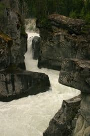
There are two lookout platforms at the waterfall. Both are situated on a a large rock outcropping peering down at the falls. The lower lookout provides views of the river and some of the lower portions of the falls. The upper lookout looks up and down the bedrock passages at the falls.

Nairn Falls Provincial Park is an attraction created from the combination of rivers joining together. The Rutherford Creek and Soo River empty into the Green River further up in the mountains creating one powerful surge. The river tumbles its way down the mountainside, reaching a narrow channel of bedrock forming Nairn Falls. The waterfall carves a path crashing down 60 metres (195 feet) through a maze of bedrock.

This fast flowing river carries sand and gravel in the current, which form whirlpools carving potholes into the bedrock. Over time underground waterways are formed through the bedrock so, eventually, the river passes underneath through the bedrock passage. Look carefully, where the water wells up, and you can spot some of these underwater passages.

From the Nairn Falls Provincial Park parking lot is a trailhead to One Mile Lake Trail which is about a 2 kilmetre hike north through forest and wetlands to another lake. The hike to the lake is a good opportunity to view birds and other water fowl.

Explore Nairn Falls Provincial Park near Pemberton, British Columbia, Canada

Address:

Nairn Falls Provincial Park
Highway 99
Pemberton
Canada

How To Get ToNairn Falls Provincial Park

:
Travel south of Pemberton, BC, Canada on Hwy 99 (Sea to Sky Highway) for approximately 3 kilometres (2 mi.) to the parking lot of the Nairn Falls Provincial Park.
No reviews yet for Nairn Falls Provincial Park.
Hiking With Your Children - Canadian Rockies Family Hiking Guide
Explore British Columbia
Find what Birds to Look For in this Park

Come Experience the Nicola Valley!