


Join Us
Join Us


Merry Creek Trails is a small network of loop trails exploring a watershed located south of Castlegar, BC in the Kootenay region of British Columbia, Canada. The network consists of three main hiking trails - Big Cedar Trail, Merry Valley Trail and the Columbia Trail.
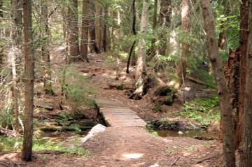
The highlights of the Merry Creek Trail system are the points of interest, information signs, birding wildlife, viewpoints and the foot bridges crossing the creeks and brooks. The waterways located in the watershed include Merry Creek, Iverson Creek, Milestone Brook and Trillium Brook.
Combined, the hiking trails provide 5 kilometres of adventure. During the summer months the trails are popular for hiking, walking, self guided nature tours, photography and birdwatching. In the winter the trails are used as cross country ski routes.
The trail system provides an opportunity to learn more about the environment and provides an opportunity to hike to viewpoints looking out over the community of Castlegar, the confluence of Kootenay and Columbia Rivers, Merry Creek watershed and out at the Bonnington Mountain Range.
From the south trailhead entrance, the trail starts as a double wide hiking trail for a few hundred metres before leading to a junction. At the junction the Merry Creek Trail goes right and the Big Cedar Trail goes left. Both trails lead to a self guided interpretive loop trail and a couple of viewpoints.
The trees most common in the watershed area include hemlock, spruce, white and yellow pine trees. History is also hidden among the trees like some evidence of past horse logging mills, remains of some of the early settlements and evidence of the 1925 Westly Fire.
Birdwatching is an activity enjoyed while hiking the Merry Creek Trails. During our visit the birds were singing as soon as we got out of our vehicle. The birds kept singing as we hiked the trails. Some of the recorded bird sightings in the area include finches, sparrows, warblers and thrushes.
The trails in the Merry Creek area are very well marked. There are some pit toilets a couple hundred metres from the trailhead entrance. Please bring your own water and good hiking boots. Do not wander off the trails disturbing the sensitive eco system. Pack out what you pack in and do not leave a footprint.
Address:
