Grey Mountain

Difficulty: Easy - Family
Park Amenities:
Grey Mountain
Grey Mountain (a.k.a Canyon Mountain) is a sightseeing and hiking destination located southeast of the community of Whitehorse, Yukon Territory, Canada. The mountain is part of a protected Greenbelt Park Reserve which is a top destination for many summer and winter activities when in the Whitehorse region.
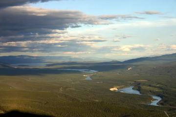
 The reserve includes and protects Chadburn, Schwatka, Chadden, Ear, the Hidden Lakes, Miles Canyon and Grey Mountain, as well as, a portion of the Yukon River. The Yukon River, the many lakes and the mountains located in the reserve are connected by a series of gravel roads and recreation trails.
Throughout the reserve are day use sites, picnic shelters, warming huts, recreation trails, viewpoints and interpretive signs. The Grey Mountain recreation destination provides far reaching views and mountain peak hiking and mountain biking adventures.
Grey Mountain is both a sightseeing viewpoint and an alpine recreation trail exploring along a ridge leading to two mountain peaks.
The sightseeing viewpoint is located at the communications tower on Grey Mountain. The tower is perched on a large rock outcropping. Views from the tower reach out over the entire valley, overlooking many lakes, rivers and mountains in the Greenbelt Park Reserve. There is a 1.5 kilometre access trail from the tower which hooks up to the main hiking trail.
The trailhead entrance to the main hiking trail is back down the mountain. You probably did not notice it. On the way up, about 1-2 kilometres in , there is a bent steel rebar pole with a beaten up reflector on it. Near it is a small wagon road like parking lot area. This is the trailhead that begins the 7 kilometre elevation hike to the first peak.
The moderately difficult hiking trail follows along a rocky ridge leading up to a mountain peak. There are views of the valley below. And wildlife sightings may include Dell Sheep and ptarmigans. Along the trail there are limestone slabs and rocks polished by winds and time. The limestone shavings sometimes have plant and animal markings embedded in them.
There are no services on this hike. Prepare well before departing with layered clothing, water, snacks and good hiking boots. The weather conditions can change quickly in the alpine. Winds can pick up fast. Clouds can move in. We all know that hiking high mountain ridges with loose limestone slabs and rocks makes for tough footing in the best of weather. So prepare well.
The hiking trail does continue from the first peak to the second peak for the hearty hikers. The trail is more of a wilderness route but it is relatively easy going. However it is not as well maintained and lacks trail markers so stay alert and on the path. The 3 kilometre extension trail leading to the second peak opens up views which reach as far as Marsh Lake near Tagish, Yukon.
Address:


