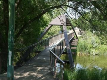
Devonian Pathway

Trail Length: 8 km
Difficulty: Easy - Family
Park Amenities:
Devonian Pathway - Regina, Saskatchewan, Canada
Devonian Pathway is one of the more popular recreation trails for outdoor activities and sightseeing when visiting in the City of Regina, Saskatchewan, Canada.
The trail acts as a recreation activity route, as well as, a transportation route providing access to downtown Regina and connecting with Wascana Centre Park. The northwest trailhead for the Devonian Pathway is located on Ritter Avenue and the southeast trailhead is located just off Albert Street.
 The Regina, Sask., Canada pathway is very wheelchair and baby stroller friendly. The activities enjoyed on the 8+ kilometre paved pathway are year round. Some of the activities enjoyed in the summer months include walking, biking, roller balding, picnicking, jogging, sightseeing and birdwatching. During the winter months the route is used as a xc ski trail.
The Devonian Pathway follows the banks of Wascana Creek eventually connecting to a long series of green space parks. Starting from the northwest trailhead the parks include the A.E. Wilson, Optimist, Grassick, Empress, Rambler, Les Sherman, Kiwanis, Rotary Parks and Wascana Centre Park.
Each smaller park is unique. Some include sightseeing benches, grass lawns, picnic areas, playgrounds, spray parks and recreation facilities like soccer and baseball fields. Located along the route are pit toilets and washrooms. The Wascana Centre Park provides much more in services and amenities.
Many of the recreation trails in Regina are connected by access trails and side streets. On the northwest end of the Devonian Pathway it connects, via a secondary trail, to the North Storm Channel Pathway and on the south end it connects to the Wascana South Pathway located in the Wascana Centre Park.
The City of Regina enjoys a large network of recreation trails and some secondary connector trails. The recreation routes include the North Storm Channel Pathway ( 4.5 km), Devonian Pathway ( 8.8 km), Pilot Butte Creek Pathway ( 3.2 km), Wascana Park South Pathway ( 9.5 km) and the South Storm Channel Pathway ( 0.8 km).
Address:


