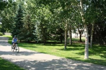
North Storm Channel Pathway

Trail Length: 4.5
Difficulty: Easy - Family
Park Amenities:
North Storm Channel Pathway - Regina, SK
North Storm Channel Pathway is a recreation trail popular for outdoor activities and sightseeing when visiting in the City of Regina, Saskatchewan, Canada. It is one of many trails ideal for viewing the city and for traveling throughout the area.
The activities enjoyed on the 4.5+ kilometre paved pathway are year round. Some of the activities enjoyed in the summer months include walking, biking, roller blading, picnicking, jogging, sightseeing and birding. During the winter months the route is used as a xc ski trail.
 The pathway runs in an east-west direction, following a waterway canal, in the northern part of the city. The western trailhead for the North Storm Channel Pathway is located on Dorian Road and the eastern trailhead is situated just off of Albert Street.
Many of the recreation trails in Regina, Sask., Canada are connected by access trails and side streets. There is an access trail from the Devonian Pathway which connects to the middle point of the North Storm Channel Pathway near Button and Ken Jenkins Parks.
There are many day use parks located on the North Storm Channel Pathway. The green space parks including the Westhill Park, Venture Park, Murphy Park, Ruth Buck Park, Button Park, Ken Jenkins Park, Arthur Park and Ellison Park.
Each smaller park is unique. Some include sightseeing benches, grass lawns, picnic areas, playgrounds and access to recreation facilities. Located along the route are pit toilets and washrooms.
The City of Regina enjoys a large network of recreation trails including the North Storm Channel Pathway ( 4.5 km), Devonian Pathway ( 8.8 km), Pilot Butte Creek Pathway ( 3.2 km), Wascana Park South Pathway ( 9.5 km) and the South Storm Channel Pathway ( 0.8 km).
Address:


