Wawa
Ontario
Canada
Park Size: 187,000 hectaresPark Amenities:
Pukaskwa National Park is a recreation, campground and historical park destination located near the town of Marathon, west of the community of Wawa, in Algoma Country, Ontario, Canada.
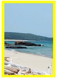
The northern Ontario park measures 187,000 hectares (462 acres). The park is located in the northern boreal forest region of Ontario and includes such natural features as lake shoreline, sandy beaches, waterfalls, whitewater rivers, rocky cliffs and remote coves.
The natural environment of lake, rivers and forest is home to various wildlife species including caribou, moose, lynx, black bear and grey wolves.
Activities enjoyed in the Pukaskwa National Park include hiking, backpacking, camping, canoeing, swimming, picnicking, fishing, boating, sailing, birding, wildlife sightings and history.
Located in the park is a First Nation encampment which features the culture and traditions of the Anishinaabe/Ojibway people. Onsite there is a teepee village, wigwam and interpreters. The interpreters are local First Nation elders who share stories and serve you bannock and herbal teas.
The Hattie Cove Campground and day use picnic area in the park are the main jumping off points for activities. There are serviced and non serviced campsites. Services include comfort station, washrooms (showers), firewood and pit toilets.
From the campground visitors can access hiking trails, boat launch, water taxi tour and canoe paddle routes.
Trails in the Pukaskwa National Park include :
Beach Trail (1.5 km) : A easy going, family friendly route following a boardwalk trail down to Horseshoe Beach.
Manito Miikana Trail (2 km) : Referred to as the "Spirit Trail". An elevation trail leading to 2 sightseeing viewpoints providing views of sand dunes and Lake Superior.
Southern Headland Trail (2.2 km) : A semi challenging trail leading up to views of Lake Superior, Pulpwood Harbour and Horseshoe Bay.
Bimose Kinoomagewnan Trail (2.6 km) : An interpretive trail exploring around Halfway Lake. Information along the route shares some of the culture and traditions of the Ojibway First Nation people.
Coastal Hiking Trail (60 km one-way) : A 5-7 day trail exploring the northern rocky shoreline of Lake Superior. Highlights on the route include Chigamiwinigum Falls, Hook Falls, Hideaway Lake, Oiseau Bay, Fisherman's Cove, sandy beaches, suspension bridges and a boat tour (water taxi for pick up or drop off).
Along the Coastal Hiking Trail are backcountry campsites with tent pads, pit toilets, food storage lockers and fire pits. The trail forms part of the long-distance Voyageur Hiking Trail.
The main canoe route in the park follows the shores of Lake Superior and is called the Coastal Paddle Route. Main put-in point is located at Hattie Cove. One can paddle south along the Lake Superior shoreline from the cove or take the water taxi and then paddle north back to Hattie Cove. The entire one-way paddle is about 90 kilometres and takes 5-7 days.
Address:
Pukaskwa National Park
Highway #627
Wawa
Canada
How To Get ToPukaskwa National Park
:
How to Get Here: Travel to the community of Wawa, Ontario. From Wawa travel towards the town of Marathon, Ontario. Just prior to Marathon take the Hwy #627 exit. Continue for 15 kilometres to the park. Pukaskwa National Park is approximately 164 kilometres from Wawa.
No reviews yet for Pukaskwa National Park.
