Sightseeing on the Port au Port Peninsula, NL in Summer and Winter
Adventures on the Port au Port Peninsula in Two Seasons
Visiting the Port au Port peninsula is an exciting prospect at any time of year. Located on the west coast of NL, the Port au Port Peninsula is connected to the island of Newfoundland by a very narrow isthmus. Despite being a relatively small land mass, like many regions of Newfoundland, it is packed with things to do and see. Some sights are seasonal and some can be seen or accessed at any time of year. The Peninsula offers geological sites, hiking, kayaking, cultural history, and sightseeing. I've visited twice, in July and March and I have thoroughly enjoyed each visit.
Getting to the Port au Port peninsula is an 811 km drive from St. John's International airport. The Trans-Canada Highway is travelled for most of the trip – about 735 km, at which point Route NL-460 W is taken to reach the peninsula. Other centres located closer to the peninsula include Deer Lake, which has a regional airport (177 km), Corner Brook (125 km) and Stephenville (43 km). Depending on how much time you have, making some stops along the way to sights is a good way to break up the drive.
At 130 km in area the peninsula itself is certainly doable as a day drive. However, in my opinion, is it better to give yourself a few days to allow time to stop at the many communities and sites all along the coastline, each with something unique to offer. Additionally, it is worth doing a little research ahead of time to find all the hidden gems and understand a little more about the rich history and distinct culture of this part of Newfoundland.
Signage for the community of Jerry's Nose on the Port au Port Peninsula. It is where the kissing rocks can be found.
Standing among the rock formations, Mainland, NL
Geology of interest on the Port au Port Peninsula
Our Lady of Mercy Church was consecrated in 1925 and still stands in testament to time when the limestone mine in Agathuna was bustling with activity. It one of the largest and oldest wooden structures in NL.
Jerrys Nose is one of those interstingly names communities in NL. Turning off the main road and driving to the end the community is where you will park you car. There is no formal parking lot and not signage identifying that these rocks are there. I found these by doing my own grass roots research. If you walk to the coast from Jerry's Nose and turn right to walk along the coast line, you will find them. Do be careful around the edges as it is very cliffy.
Cape St. George is located on the southwest tip of the Port au Port peninsula. Within Cape St. George is Boutte du Cap park. This is a great idea for hiking and wildflower IDing. While there are no official services at the park, camping is permitted free of charge and there is access to outhouses and picnic tables.
Limetone rocks along The Gravels Walking Trail on the Port au Port peninsula are a great place to find fossils.
The gravel road drive out to Long Point and Blue Beach it worth it. Here you walk to the tippy top point of one of the 'finger' of the peninsula. The walking is flat and easy out to the point.
A view from the inner side of the ice.
It was great to return to Sheaves Cove on the Port au Port Peninsula and pay tour guide to my husband. The falls, which I had visited in the summer was one of the sights I really wanted to show him.
A winter trip to the Port au Port Peninsula allowed us to see the ice caves at Campbell's Creek. Campbell's Creek is located along with south coast of the peninsula. You won't get to explore these formations in the summer months!
I highly recommend this book for a fun, accessible way to find key examples of the varied geology in Newfoundand. Descriptions and gps waypoints make it possible to locate the many formations.
Sheaves Cove is located along the southern cost of the Port au Port peninsula. This is where you will find the Hidden Falls and another walking trail that takes you along the coast and provides access to more rock formations. There is signage for the turning to the Hidden Falls on the main road. Once you access the parking area, you will be able to locate the falls. There is well maintained walking trail right to them.
What nature forms can be surreal and awe inspiring. These limestone formations along the coast on the Port au Port peninsula are a great example of the interesting geology on the West Coast of NL.
Along with fossils, there are intersting shapes and contours in the limestone formations along The Gravels Walking Trail. With a little imagination you can see all kinds of things in the rocks!
Sharing a kiss at the kissing rocks, Jerry's Nose, Port au Port Peninsula, NL
A waterfall, frozen at this time of year (March) can be found further down the beach. About 1 km toward the south after you enter the beach.
The ice caves at Campbell's Creek, Port au Port Peninsula, West Coast of Newfoundland.
Looking out from the inside of hte ice over hangs, Port au Port, NL
In addition to free camping there are several places you can walk in Boutte du Cap park. It is also home to two kittiwake colonies and a great place to see minke whales in the summer.
Kayaking along The Gravels Walking Trail, Port au Port NL.
Boutte du Cap park has a traditional Acadian bread oven that is available for public use. There are demonstrations and bread tastings available in the summer.
Mainland, on the western side of the Port au Port Peninsula is also home to some very interesting geology which can be accessed from the beach. This is another site included in the Hickman Hild geology field guide.
The sign points you to a gravel road which could be mistaken for a driveway, but continue on down to parking area (in summer) where the falls are easily finable. In winter, the road was not cleared the snow was not too deep to make it impassable. On this visit we walked in the road. From there we took a sharp left get onto to the trail to the falls.
Finding the Mainland, NL outcrop described in the field guide.
Piccadilly is a community found on the easterly side of the pensinsula. Camping is available at Piccadilly Head Regional Park. You can access the park during the day for a nomial fee. There is a wonderful stretch of sandy beach which is where I located the folded rocks as described in my Geology of Newfoundland Field Guide by Martha Hickman Hild.
Being able to get out of our kayaks and have a look in the cave was very cool. Photo credit: Lori Deeley
The blue dot on the image is me. I walk to walk right to the bitter end of the point and screenshot my location on my Garmin track.
Our kayaks, the sky and the ocean make a beautiful vista from inside the limestone cave.
Visiting the Port au Peninsula in Summer
July of 2024 was the first time I visited the Port au Port Peninsula. It had long been a wish of mine to see this part of the province. Before leaving I did some pretty intensive research to get to know the area and to figure out what I wanted to see. I had four days in this area which gave me plenty of time to poke around. Besides the obvious results from an internet search, I also found some localized and more grass roots online content that was very useful for planning my trip. Finding places to stay is easier in the summer months when seasonal accommodations are open. Additionally, places to eat and many of the cultural attractions in the area are only open in the summer season.
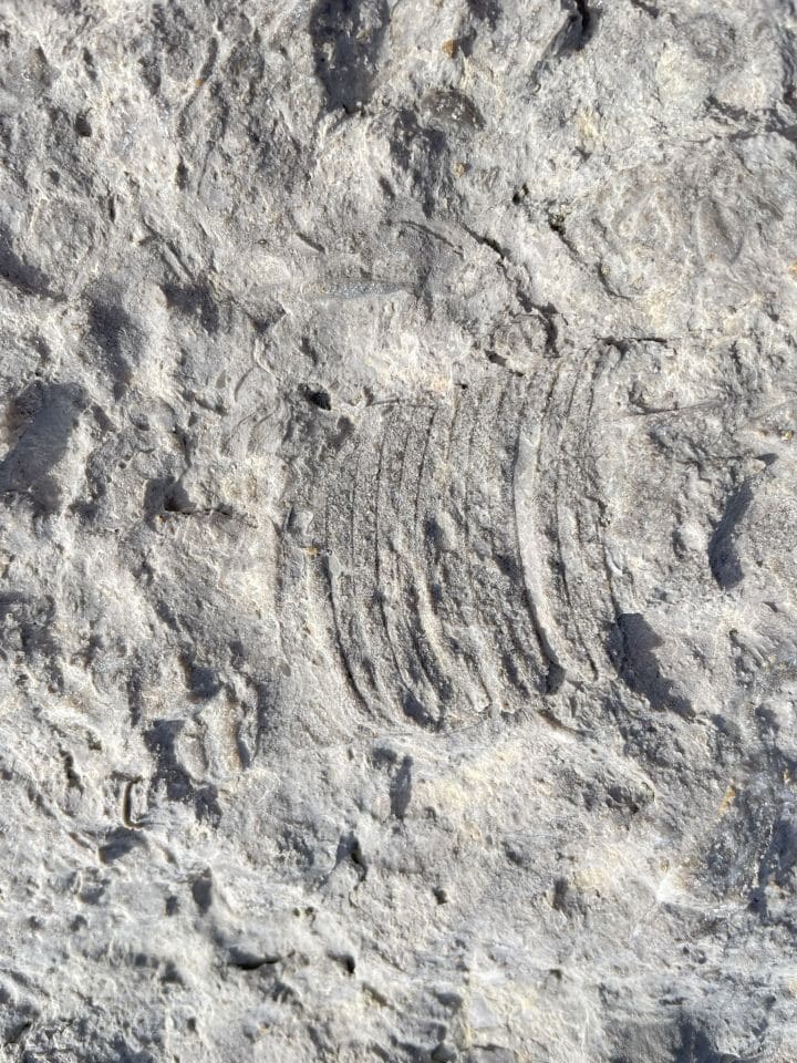
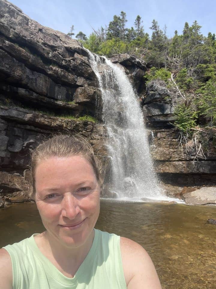
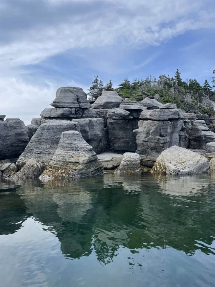
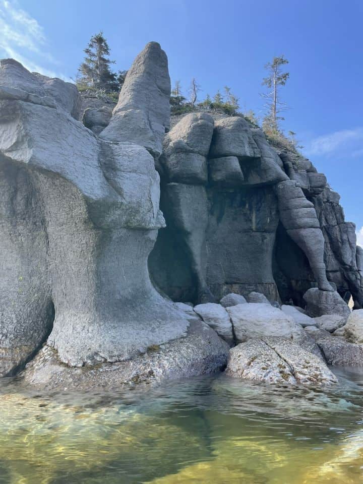
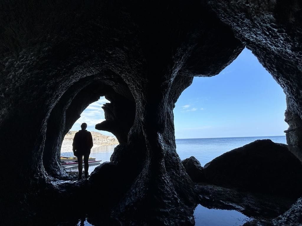
During my summer trip I drove the peninsula making stops in several communities including Sheaves Cove, Jerry's Nose, Tea Cove, Mainland, Blue Beach, Cape Saint George, Lourdes, Piccadilly. Highlights included finding the
kissing rocks in Jerry's Nose, hiking in Boutte du Cap Park in Cape St. George, enjoying delicious seafood chowder and a sweet treat at the Tea By the Sea tearoom in Mainland and tracking down the folded rocks in Piccadilly using my Geology of Newfoundland field guide. Perhaps my most jaw-dropping experience was kayaking the coastline along The Gravels Walking Trail. The limestone formations were otherworldly.
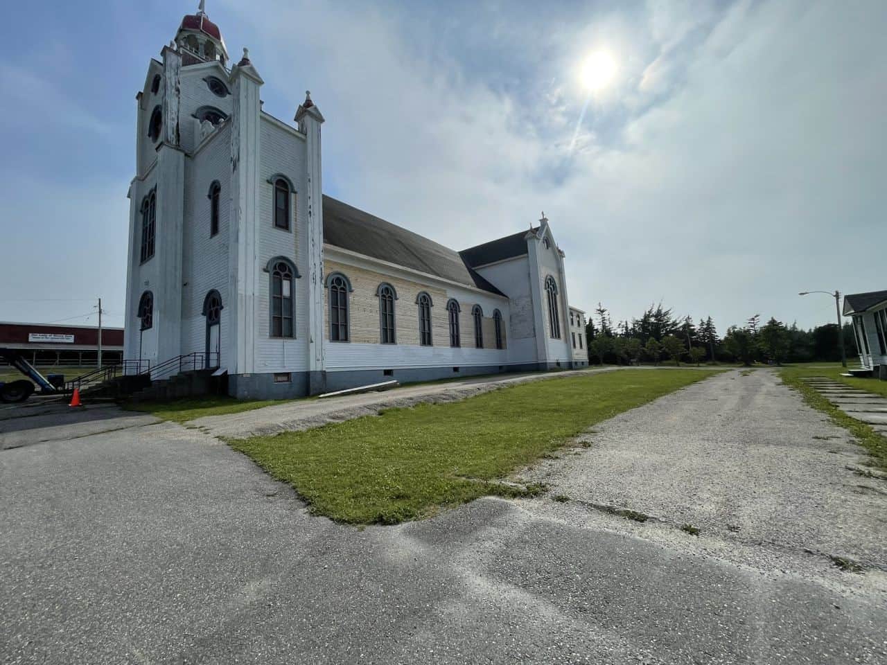
Along with the sightseeing were opportunities to learn more about the rich and unique history this part of the province. The driving route around the peninsula is known as the France Ancestors Route in acknowledgment of the Francophone history. Many place names on the peninsula are French or have French origins. A traditional Acadian bread oven, still available for public use in Cape St. George is a testament to this culture. Another important part of the history of the Port au Port region was the presence of Mi'kmaq First Nations, possibly from before the time of European contact. Mi'kmaq and French cultural revitalization is alive and well making the Port au Port Peninsula one of the most culturally dynamic places to visit in the province.
Visiting the Port au Port Peninsula in Winter
My winter trip to the Port au Port Peninsula happened in March of 2025. This time I was accompanied by my husband who had never explored this region before. It was fun to be able to play tour guide and to visit a few new places. Accommodation during this time of year was harder to come by, but we managed to find a place to stay not far off the peninsula in the small community of Cold Brook. One of the things I really wanted to see was the ice caves at Campbell's Creek. Campbell's Creek is located on the south coast of the peninsula. I had seen others posting pictures of these on local Facebook pages and was excited to see them for myself. They did not disappoint! Obviously, this is a very seasonal highlight that can only be seen at a particular time of year.
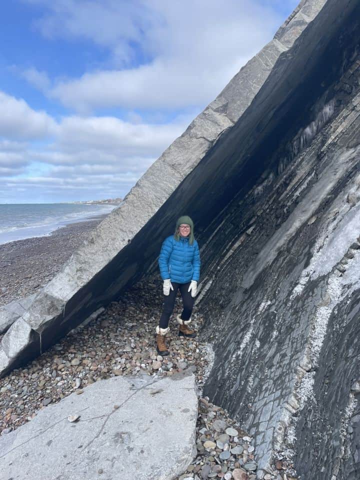
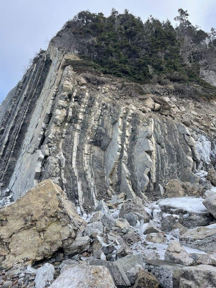
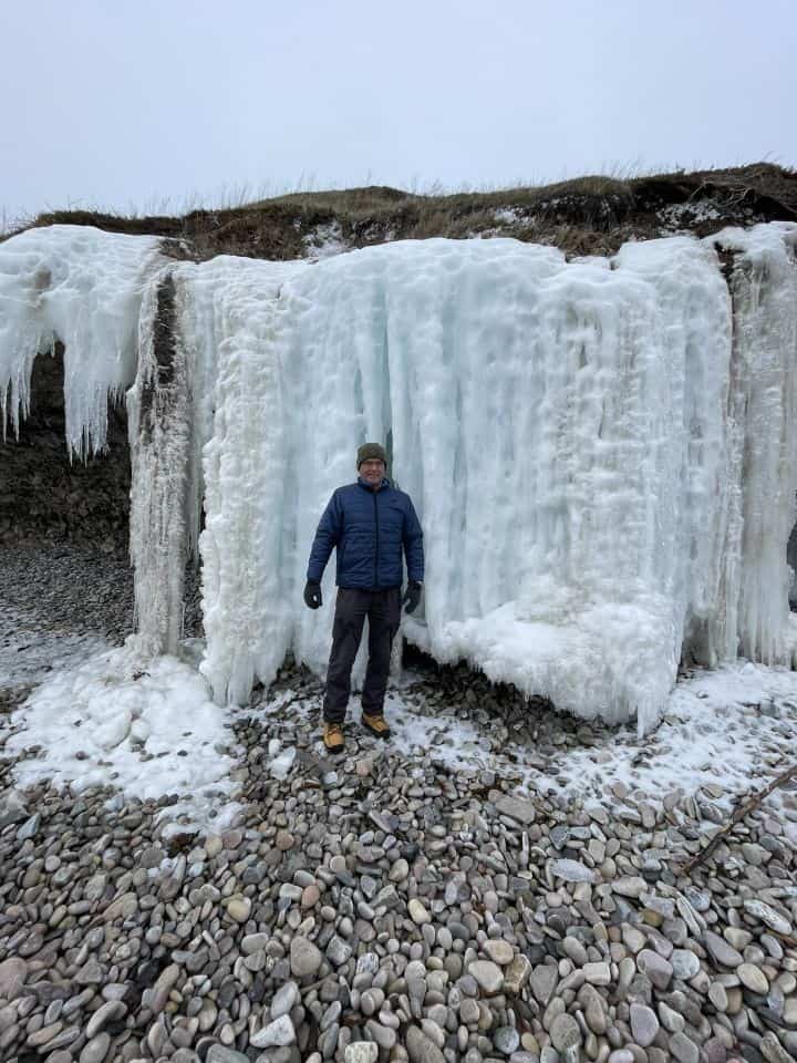
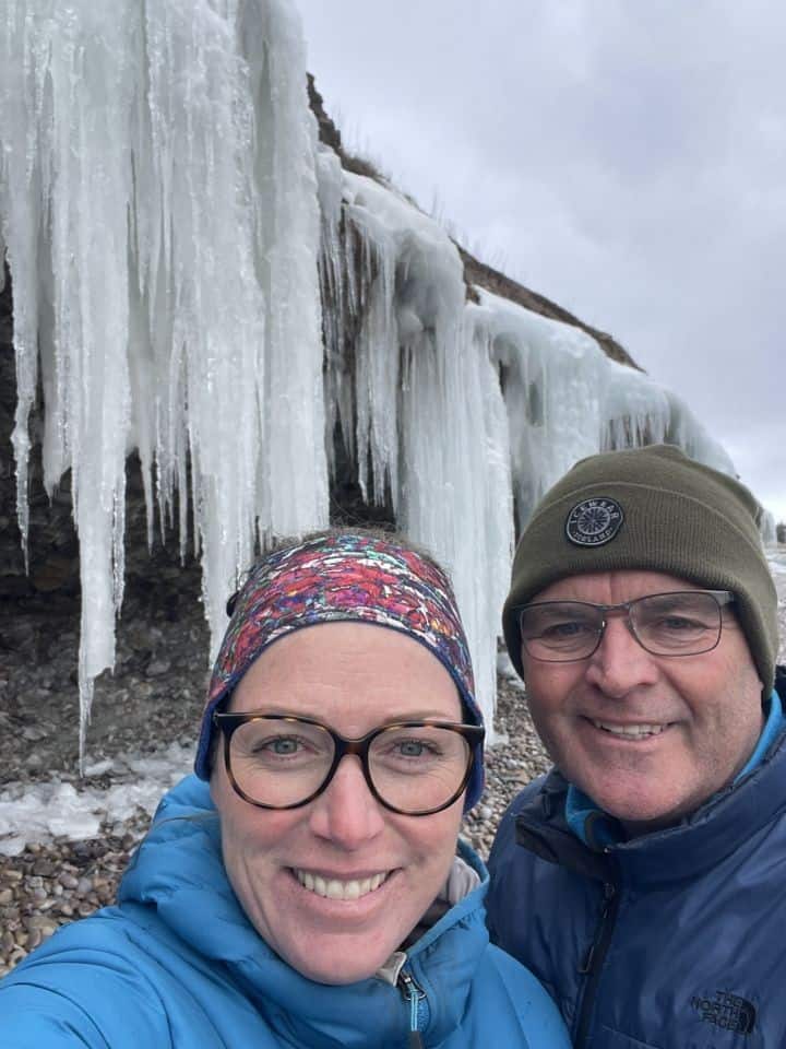
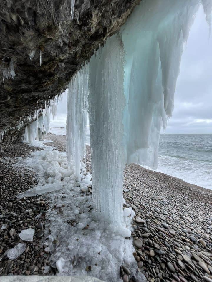
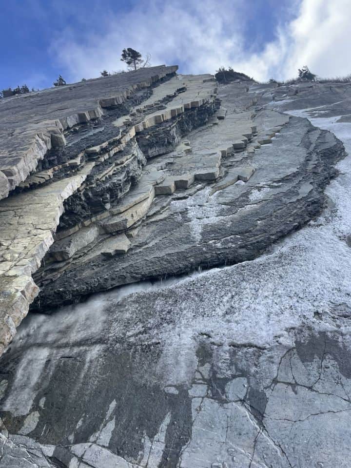
Revisits included the kissing rocks at Jerry's Nose, a favourite of my husband's and the Hidden Falls at Sheaves Cove. Although the gravel road to the falls was not cleared of snow it wasn't deep and so quite easy to make it all the way to the Falls. From there, we also visited the beach in Mainland. Although I had been in this community before, I hadn't been to the beach. The geology on Mainland beach is another site included in the
Geology of Newfoundland field guide. My husband and I had our breath taken away by incredible layers of rock. The descriptions in the guide really add to the experience and help you learn what you are looking at.
Given the time of year, the cultural attractions and eating establishments were not operating which made it a different kind of trip than my summer trip. We cooked for ourselves in our cozy accommodation or went to Stephenville, a larger centre to eat and get supplies. If we had time for a longer trip, we may have partaken in some winter hiking or other types of activities like snowshoeing or snowmobiling, however, this trip was only for two nights so we had limited time.
When is the better time to visit the Port au Port Peninsula, summer or winter?
Not surprisingly, the answer to that really depends on what you are looking for and what types of activities you enjoy. For me, I do think the summer visit wins simply because more things were open, providing a better balance of outdoor and cultural / historical activities. Also, kayaking in the summer is more pleasant and requires less gear. Saying that, for those who enjoy snowmobiling, ice fishing and other winter activities, the west coast of the province is a very place popular place to participate in these activities. The west coast of Newfoundland gets more snow than the east coast, so it attracts a lot of winter adventurists.
In closing, although I feel my summer trip has a slight edge, I feel very privileged to have had the opportunity to see some winter specific sights in the region and to share some of my summer highlights with my husband on my second trip. All in all, you cannot lose when visiting the Port au Port Peninsula no matter the time of year!
Visiting the Port au Port Peninsula, Newfoundland
Adventures on the Port au Port Peninsula in Two Seasons
Comments 2
I would love to be there with my camera. Your photos look great too!
Farah you do have a great collection of selfie photo and geography. Nice combo.