Ganges
British Columbia
Canada
Park Size: 231 hectaresTrail Length: 6 km in totalDifficulty: Easy - FamilyPark Amenities:
Mount Maxwell is a day use park located on Salt Spring Island, BC, Canada. Salt Spring is part of the southern Gulf Islands Group on the west coast of British Columbia, Canada.
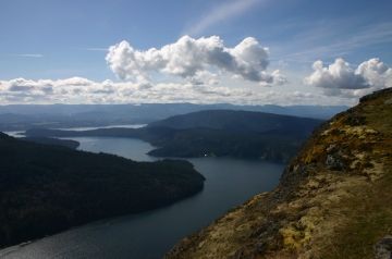
From the Baynes Peak Summit on Mt. Maxwell the mountain park enjoys ocean, mountain and island views attracting many to the viewing park every year.
The park is accessible by vehicle via a rough mountain dirt road. From the parking lot are some short trails leading to viewpoints overlooking the Gulf Islands. It is the highest point on Salt Spring Island. There are some amazing views of Burgoyne Bay and the Sansum Narrows.
Mount Maxwell was established in 1938. The entire park stretches 231 hectares from the top of Mount Maxwell across to Burgoyne Bay and including Mount Bruce. The park was established to protect the 3000 year old First Nation middens, an ecological reserve and a Garry Oak eco-system.
There are plenty of hiking opportunities in the mountain park . Some of the hiking trails explore a forest while some lead to more viewpoints. There are over 6 kilometres of hiking trails in all - some easy , some hard. However the trails leading to the viewpoints are no longer than 150 metres and are easy going.
The viewpoints are protected by chain link fencing. Do not climb the fence at any time as it is a long way down. In the distance one can see speed boats, sailboats and yachts. Some are just dots on a large ocean blue canvas. There are views of islands and ocean channels just like you see on a map. In the air are sea gulls diving and Bald Eagles soaring.
The elevation from the main viewpoint on Baynes Peak is 602 metres (1975 ft). To the right are the islands and ocean channels. To the left are rows and rows of farmers fields, laid out like a chess board, with ocean on both sides. And below is the Mount Maxwell Ecological Reserve.
Located at the main viewpoint in the park are some sitting benches and large rock boulders. Both used as seating and sightseeing perches. There is a short path following the fence line leading to different vantage points overlooking the islands.
Mount Maxwell Park is family friendly and good viewing for all ages. The trails to the viewpoints are short and easy. It is a safe environment for great marine views. Bring a picnic. There are picnic tables and pit toilets near the parking lot - but not near the viewpoints.
The road up the mountain is very narrow with many pot holes. Motorhomes or RVs are not permitted on the road up to Mt. Maxwell.
Mount Maxwell Park, Salt Spring Island, Gulf Islands, BC, Canada (Saltspring Island)
Address:
Mount Maxwell Provincial Park
Mount Maxwell Road
Ganges
Canada
How To Get ToMount Maxwell Provincial Park
:
How to Get Here: Follow Lower Ganges Road into the Village of Ganges. From the village continue south on the Fulford Ganges Road to Cranberry Road. Continue on Cranberry to Mount Maxwell Road. Turn right and follow narrow gravel road to parking lot.
From Crofton (BC Ferry Vesuvius Terminal) : From the Crofton BC Ferry on Saltspring Island drive Vesuvius Bay Road. At the stop sign on Northend Rd | Lower Ganges Rd take a right towards Ganges Village. Follow the road into the Village of Ganges. From
No reviews yet for Mount Maxwell Provincial Park.
